Flag Hill and Vista Grande and a few hazards
On Tuesday, Ralph and I headed out for Sunol Regional Wilderness in Alameda County —eagerly looking forward to climbing to two peaks in the park — Flag Hill and Vista Grande. These would be #41 and #42 for us on the ‘Nifty Ninety’ Peaks challenge that we have been pursuing since the Sierra Club Bay Chapter issued their challenge back in December 2017.
Sunol Regional is a popular destination on the weekends, but rather quiet on weekdays. In fact, we saw no one else on our trails during our 7+-mile hike.
The S.F. Bay Area weather has been quite varied the last couple of weeks. Sunol can easily climb into the 90s and even 100s during hot spells, but on this particular day, it stayed comfortable. It was 70s during most of our hike with a cooling breeze while we were on the peaks. As we came back down from the hills, the temperature rose, but by that time we were done with our explorations.
 Flag Hill
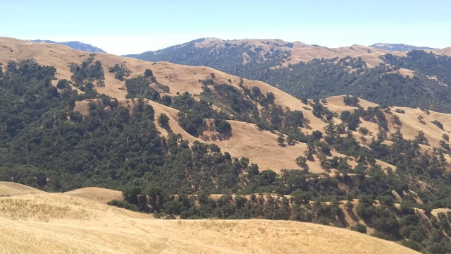
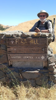
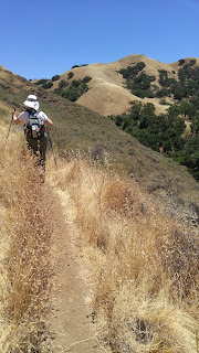
Our route: The climb to Flag Hill (1,360 ft) is described as steep and strenuous. The Flag Hill Trail (which starts just behind the Visitor Center on a small wooden bridge) climbs about 900 feet in 1.26 miles. We reached the marker, then walked to the top of the hill right behind it — and in the process picked up dozens of stickers in our socks!
The rewards were several however — the workout itself, of course, but also views of the park and Calaveras Reservoir. The occasional giant Oak trees provided welcome shade as we switch-backed through grassland on a narrow, dirt trail (with a few rocky sections).
 From Flag Hill, we followed a more moderate route going north and then east onto Flag Hill Road for .78 miles where we reached an intersection and went straight onto the Vista Grande Road (another wide dirt road). I enjoyed looking over to the Northeast and seeing the challenging Maguire Peaks that we had hiked a couple of months back.
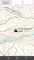
Vista Grande
Finding the peak of Vista Grande, at 1840′, was a bit more difficult than finding Flag Hill had been. There wasn’t a signpost or survey marker to show the point, but our GPS located the spot we wanted—the highpoint in the middle of a grassy mound.
 The hazards: Our two peaks located, we doubled back on Vista Grande, and stopped to eat lunch with views and a bench at the intersection with Eagle View.
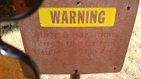
As we proceeded down onto Eagle View, we were startled to find a sign that urged care. The “No Bicycles or Equestrians” wasn’t unusual to see, but the “Steep and Hazardous Terrain, Use Extreme Caution in This Area” was a bit ominous. As we rounded a curve and saw what lay ahead, I considered turning back, but I didn’t want to climb back up the hill and figured that if we were careful, we would be ok.
As I led the way, I had two concerns. The first was that the hillside was very steep and a fall would lead to a tumble a couple hundred feet down the slope. Secondly, we were in prime rattlesnake and tick territory. As I proceeded, I used my hiking poles to keep me steady and I scanned the grassy slopes to spot any snakes. I kept telling myself that if I were to see a one, I should not jump or lose my balance.
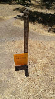 Bee nest ahead: I was very happy, and relieved, when we finished that section of the trail and descended to cross a small creek. We continued our descent on the Rocks Trail and Indian Joe trail. We’d planned to continue on Indian Joe, but a hand-lettered sign, “BEE NEST AHEAD” convinced us to turn onto the wide Hayfield Road the rest of the way down the hill where we crossed on the wooden bridge again and returned to our car.
This was a wonderful and exhilarating hike with enough challenge to leave me feeling I had worked to complete these peaks! Grateful for a break in the hot spell; generally this hike is best done in the spring or fall. (You’ll enjoy more wildflowers in the spring.)
Additional resource: General overview of Sunol hikes.
Date hiked: June 26, 2018. (Our 41, 42)