Encompassing Views of Montara Mountain, North Peak
Our little team has been wanting to do some more #Nifty Ninety Peaks, but we were in agreement that we didn’t want to do them in the 90+ degree conditions of the inland valleys. Since the weather pattern of the S.F. Bay Area brings fog to San Francisco and nearby coastal areas during the summer, we just had to wait for our opportunity. That happened the last weekend of July.
 We elected to hike Montara Mountain along the San Mateo coast first. Another friend, Patricia, had researched various roads into the hills and had selected the trails that we would follow.
A bit of history
The Trout Farm Trail took us past a few picnic table and benches. We found some informational signs that described what the Trout Farm had been — a place where visitors could come to picnic and fish. John and Mary Gay ran the farm. John built several round tanks for raising fish, and a fishing pond. Families rented poles, then stood or sat on logs alongside a pond, and would be charged according to the size of any fish caught. The trout farm was operated by John Gay until 1962, when storm rains washed out the operation; today, only a few pieces of the breeding ponds remain.
Back on the trail
The trail ascended alongside the south fork of San Pedro Creek for a while. We could hear, but rarely see the water, but assume it would be roaring during the rainy season. The seasonal water is part of Pacifica’s water supply and is a major steelhead trout habitat.
 At 0.5 miles along, our trail met the Brook Creek Trail. Turning left, we continued uphill. I was impressed at how well maintained the trail was and appreciated the fact that we had switchbacks to make it easy. Another 0.7 miles uphill, we met the Montara Mountain Trail, and turned left, uphill again.
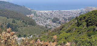
Views from the peak and along the way, had been great — depending where we were standing, we could see down into Pacifica, out to sea, miles of wild open space, across the the channel to Mount Tamalpais in Marin County, and across San Francisco Bay to Mount Diablo.
Back downhill
T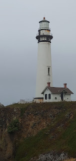 he descent was easy — we retraced our steps until we came to the intersection of Brooks Creek and Trout Farm where we kept left to stay on Brooks Creek. Total distance was 8-8.5 miles.
Then we headed for our accommodations for the night — the Pigeon Point Hostel & Lighthouse. The following day we were set to go on Peak #75— Chalk Mountain, a bit further south on Highway 1. Link is here.
hiked: 7/28/2019 Peak #74 for us