Discovering Almaden Quicksilver County Park
At the end of June, Ralph and I and our good friend Patricia Schaffarczyk headed for Almaden Quicksilver (mercury) County Park, part of Santa Clara County Parks. We wanted to climb Mines Hill (1,728 ft.) and Church Hill (1,400 ft.) both easy summits that are part of the Nifty Ninety Peaks challenge.
As it turned out, the choice of Almaden Quicksilver as our day’s destination was a good one; we had temperatures in the 70s with clear skies and the trails were almost deserted.
The Almaden Quicksilver facilities
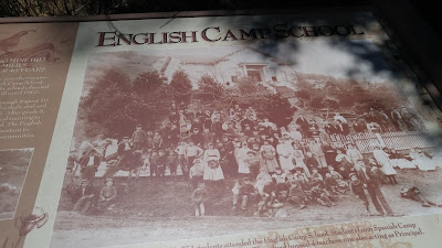
We found the Almaden Quicksilver park well maintained with clean restrooms and water at the entrance and well-maintained trails throughout. The parks department and the Boy Scouts of America have done a great job putting up informational signboards. The park does get a demerit, however, for not putting trail markers to the peaks.
There are three park entrances: Mockingbird, Wood, and Hacienda–no entrance or parking fees are charged. We came in on the Hacienda entrance passing the Casa Grande and Almaden Quicksilver Mining Museum along the way. It was closed this date, but we had visited it previously and can recommend a visit. Call (408) 323-1107).

Our route on Almaden Quicksilver trails:
Our loop from the parking lot climbed gradually on the Mines Hill Trail. At the first intersection, we continued on the Mines Hill Trail (which was now marked as part of the Bay Area Ridge Trail) heading south.
At the next intersection, we turned left (SE) toward the English Camp on the Castillero Trail. (Alternately, one could follow the Yellow Kid Trail and see Spanish Town, Rotary Furnace and the Hidalgo Cemetery, but that was a longer route.)
The cemetery is a grassy area with a line of cypress and surrounded by a picket fence, but no grave marker) From the Castillero/Yellow Kid Trail intersection, we used Maps.me to locate the unmarked Mine Hill.
 After the short climb to the summit (with a bit steep and with loose rock), we retraced our steps back on the Castillero, went again through English camp, and climbed the narrow, dirt, unmarked trail up to Church Hill. From an open area near the summit, we had good expansive views over the park.
Rather than retrace our steps back to the parking lot, we followed the wide, dirt Deep Gulch Trail about a mile downhill. The deeply shaded passage was a perfect contrast to the exposed trails we had been following. Depending on the season, the creek below the trail can be running hard, but in late June, there was little water.
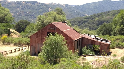
At the bottom on the incline, we made a left to follow our narrow trail through a field, which took us alongside the former site of the Hacienda Reduction Area (where mercury was extracted from cinnabar ore and made liquid). Here we found an interesting collection of old mining equipment.
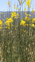 Note: Check the weather report before you go. Temperatures during the summer can easily hit 90s or more. Take plenty of water, wear sunscreen, a hat, and even a hiking umbrella. Springtime usually brings an abundance of wildflowers. In June and July you will see the bright, colorful, broom shown here.
 Almaden Quicksilver County Park is 3,977 acres. The historic park was the site of over 135 years of mining activities and former home to more than 1,800 miners and their families. All of the former mines have been sealed, but the San Cristobal mine can be viewed from behind a locked gate.
Five miles, Rated: Moderate.
More history: There is much more to the park history, click here.
More extensive route: Bay Area Hiker, click here.
Hiked June 28, 2018. Peaks 43 and 44 for Ralph and me.